Azure Maps

What are AI Agents and how Agentic AI transforms your Business

AI is no longer an abstract promise of the future. It’s here, embedded into enterprise workflows, products, and decision-making processes. From Microsoft Copilot to ChatGPT and domain-specific assistants, businesses are adopting AI at an unprecedented pace. But too often, “AI” is used as a catch-all term for a wide range of technologies. To lead the next transformation wave, organizations must move beyond generic AI adoption and toward agentic AI, a more autonomous, goal-driven form of AI that’s ready to take on real work.

Enabling Geospatial Intelligence in LLMs with Azure Maps and MCP

In today’s AI era, you’ve likely interacted with Microsoft Copilot, ChatGPT, or Claude.ai, tools powered by advanced Large Language Models (LLMs). These models excel at understanding and generating human-like text based on vast amounts of training data. However, while LLMs are impressive at reasoning and answering general questions, they fall short when it comes to performing real-world tasks or retrieving live, domain-specific information.

This is where the Model Context Protocol (MCP) comes in.

Enhancing Logistics with Azure Maps and NVIDIA cuOpt for Multi-Itinerary Optimization

The logistics industry constantly seeks efficiency in routing vehicles to deliver goods. This is where the Vehicle Routing Problem (VRP) and Pickup and Delivery Problems (PDP) come into the picture as both are sophisticated extensions of the classic Traveling Salesperson Problem (TSP). The TSP poses a simple yet challenging question: “What is the most efficient route that visits each destination once and returns to the starting point?” This problem is not just academic; it has practical applications in logistics, where optimizing routes can lead to substantial savings in time and costs.

Introducing the Unified Azure Maps Experience

We are thrilled to announce the unification of Bing Maps for Enterprise (BME) with Azure Maps, marking a significant milestone in our geospatial services at Microsoft. Azure Maps now boasts a robust stack of geospatial offerings, leveraging the powerful capabilities of Microsoft Maps, which also drives Bing Maps (our consumer maps experience). Over the past year, our team has dedicated significant time and effort to combine the strengths of Bing Maps for Enterprise into Azure Maps, enhancing our global quality and coverage.

What is it to be a Program Manager at Microsoft?

Have you ever wondered what it’s like to be a Program Manager (PM) at Microsoft? As someone who often fields this question, I’d like to offer some insights into the fascinating world of product development and customer-centric decision-making that defines the role of a PM at one of the world’s leading tech companies.

At Microsoft, our mission revolves around creating products and services that address real-world needs and deliver tangible value to our users. As a Program Manager, my primary responsibility is to delve into the evolving landscape of customer demands and technological advancements to identify opportunities for enhancing our products.

Help customers find your business with the Azure Maps Store Locator

Maximize Visibility

In today’s digital age, the visibility of your business is paramount. Once you’ve captured customer interest online, the next crucial step is guiding them to your physical storefronts. Azure Maps Store Locator streamlines this journey, offering an interactive and intuitive experience that leads customers right to your doorstep.

Simplifying Store Discovery

Creating a basic store locator using Azure Maps is already a straightforward task, involving the loading of store locations onto a map and potentially setting up a simple search functionality. However, for larger organizations managing thousands of locations and requiring advanced filtering options, a more sophisticated solution is essential. Fortunately, the Azure Maps Store Locator, combining the power of various Azure services, caters precisely to these needs.

There is a New Style of Maps Across Microsoft

We are excited to announce that we have developed a new and improved style for our maps across Microsoft. Azure Maps now utilizes the same vector tiles and satellite imagery directly as our other Microsoft mapping platforms, including our Bing Maps consumer site and more. This updated style introduces a fresh cartographic identity across Microsoft, focusing on enhancing usability, information clarity, and aesthetic appeal.

/there-is-a-new-style-of-maps-across-microsoft/0.jpg

Azure Maps Creator onboarding

Azure Maps Creator is a powerful product that transforms your static floor plans into dynamic, interactive indoor maps for your business locations. It allows you to overlay technical building plans ontop of Azure Maps, enabling the visualization of IoT data such as temperature, occupancy, and other location-based services. The onboarding process is streamlined, requiring only the preparation and uploading of your DWG floorplan files (the native file format for Autodesk’s AutoCAD software) into Azure Maps Creator.

How Microsoft uses Azure Maps Creator

In the evolving landscape of remote work and sustainability, the optimization of physical spaces has become increasingly important. Microsoft is at the forefront of this transformation, utilizing Azure Maps Creator to enhance the management of its diverse global workspaces. This product is essential for facilities managers, providing dynamic, interactive indoor mapping solutions that allow for real-time assessment of space and resources, quick response to critical issues, and seamless adaptation to the needs of a hybrid workforce—all while minimizing environmental impact.

Storing and querying your geospatial data in Azure

While Azure Maps is known for great use cases around visualizing and interacting with a map and location data, you probably also need secure and reliable storage for that data that offers the flexibility to query your (location) data. In this blog post, we explore the different options for storing and querying geospatial data in Azure, including Azure Cosmos DB, Azure SQL Database, and Azure Blob Storage. Storing and querying geospatial data in Azure is a powerful and flexible way to manage and analyze large sets of geographic information.

Azure Maps REST SDKs

Azure Maps is more than just a Map on your website. It is a complete enterprise solution for location-aware solutions. For example, you can do (reverse) geocoding of customer addresses and use an isochrone to find out withs customers a close to your store or get weather conditions for all your past sales data to know withs products sell best by rain or hot weather or get the correct time-zone for your customer by translating an IP-address to a location and get the time-zone information, or you need to know what the travel time is between two or more locations. So many scenarios and use cases you can make location aware with Azure Maps.

Add a custom WebGL layer to Azure Maps

Enhancing your Azure Maps with a custom WebGL layer opens up a realm of possibilities for rendering dynamic 2D and 3D data. While Azure Maps provides a robust set of built-in features, there are times when you may require a more tailored solution. This is where the power of a custom WebGL layer shines.

WebGL, a cross-platform and royalty-free web standard, empowers you to harness low-level 3D graphics right in your web browser. By utilizing WebGL, Azure Maps gains a performance edge, surpassing the capabilities of standard HTML canvas rendering. However, it’s important to note that WebGL’s low-level nature adds complexity and may not always align with straightforward business solutions.

Azure Maps Web Application Authentication

Introduction

One of the requirements when building a business application, which may give access to private business data, is that only authenticated employees or agents be able to see that data. So how can you use Azure Maps in combination with authentication and authorization to ensure only the people that should be allowed have access?

Our Azure Maps docs describe in detail many different authentication scenarios but the complexity can make it seem difficult to implement. This blog post will focus on our most requested authentication scenario for Azure Maps. Use the following step by step guidance to have a .NET web application embedded Azure Maps web control where only authenticated users can see the website and use the map.

Azure Maps Power BI update

The Azure Maps Power BI Visual provides a rich set of data visualizations to enhance your data with location context. In the March release of Power BI, the Azure Maps visual introduces two new tools: Geocoding capabilities and a Pie Chart layer.

Geocoding in Power BI

When dealing with data that has a location context, such as addresses or other geographic information, you might lack the precise point location (latitude-longitude) needed to plot these addresses on a map. The new geocode capabilities in the Azure Maps Power BI visual allow you to convert address data into location data directly within Power BI. The Azure Maps geocoder is flexible and can work with incomplete address information or spelling mistakes. Additionally, it supports regional geocoding for various levels, including country, state or province, city, county, postal code, and partial address data.

Azure Maps Weather Services adds three new services

Azure Maps Weather Services, which became generally available in April 2021, has recently expanded its offerings with three new services: Historical Weather, Air Quality, and Tropical Storms. These additions empower developers and companies to enhance their capabilities when it comes to weather data.

Historical Weather

The Historical Weather API provides actuals, normals, and records climatology data by day for a specified date range, up to 31 days in a single API request. Depending on the location and feature, historical data may be available as far back as 5 to 40+ years. The information includes:

Managed Identities for Azure Maps

In many enterprise organizations, there are strict processes for privacy, access, and handling of personally identifiable information (PII). Azure Maps is a global Azure service, which means it is available worldwide (except for China and South Korea), but it also needs to store metadata and logs somewhere. In addition, Azure Maps Creator is an addon for private indoor maps that also holds map data. So, where do we keep this data?

Introducing the Heat Map Layer in Azure Maps Visual for Power BI

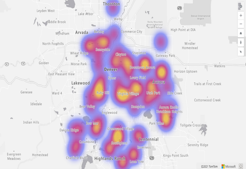
We are thrilled to announce the addition of the Heat Map layer option to the Azure Maps Visual in Power BI. This powerful feature allows you to visualize data density using various colors, highlighting data “hot spots” on a map. Whether you’re analyzing customer behavior, regional performance, or statistical trends, the heat map provides valuable insights.

Key Benefits of the Heat Map Layer in Power BI

  1. Data Density Visualization: Heat maps are ideal for rendering datasets with a large number of points. They effectively display data concentration and distribution. Use heat maps to compare customer satisfaction rates, shop performance, or any other relevant metrics across different regions or countries.
  2. Frequency Analysis: For example, by measuring the frequency with which customers visit shopping malls in various locations, you can identify popular areas and potential growth opportunities.
  3. Statistical Insights: Heat maps are excellent for visualizing vast statistical and geographical datasets. Explore patterns, correlations, and outliers with ease.

/introducing-the-heat-map-layer-in-azure-maps-visual-for-power-bi/heatmap.jpg

Use Azure Maps to calculate an isochrone to reach your customers

Imagine you are a store owner and would like to target customers that live within a 15-minute drive from your store with advertising for your weekly specials. You could draw a circle on a map, guessing that is about 15 minutes away, but it will not truly represent the time it will take for customers to get to your store. For example, a customer living near a major transit route can live further away from the store than a customer living in a less well-served part of the city. To meet this need, an isochrone is a polygon (an area on a map) of expected travel time. It represents the locations that will take the specified time, or less, it will take to get to a specific point (your store, in this case). Estimating an isochrone correctly, including all the variables like traffic, road, and vehicle conditions, is very hard to do by yourself!

Do I get wet feet? Draw a flood map using Azure Maps Elevation

Introduction

When you are living in the Netherlands you are used to that, nearly 26% of its land falling below sea level, and about 50% is just only exceeding 1 m (3.3 ft) above. The Dutch people have lived many centuries battling the water, not only from the sea but also from her rivers. To protect the land the Dutch have built many sophisticated protecting- and management systems to handle the water, like the Delta Works. Building only a dike or dam is not enough. Today we have won, but we know that we cannot rust, climate change (heavy rain showers) and sea levels are rising globally. Do we (or you) get wet feet in the future?

Create your own indoor maps using Azure Maps Creator

Introduction

When you are working inside a building, like an office, factory, shopping mall, or something like a museum. There are probably a lot of sensors that can tell you information about that building, like what is the temperature and air quality per room, is there any door open or is there some alarm happening. When you in a big building and you want to know the fastest route to a specific room/store/painting, you probably apricate some help in navigating. These are all smart buildings.